

This is a truly quiet 85km loop in the Bauges Alps (see map at bottom). It features Col de Chérel, another little known, deserted, tough, climb, that begins near Lake Annecy. Note: The top several kilometres of both cols are unpaved – I had my 29er mountain bike.
I started from Annecy beside the lake riding for 15 kilometres or so along the Annecy bike path. Always a nice way to start a ride.

For the best climbs from Lake Annecy see here.
At the south tip of the lake, I left the bike path, heading to Doussard. The far side of the village begins the small forestry road (built between 1931 and 1952) that heads up to Col de Chérel (1495 metres). It’s closed to cars after a few kilometres. The route heads up through the foret domaniale de la combe d’ire, a narrow valley, repeatedly crossing over a little torrent (the Ire) that provides a soothing sound-track for the entire climb.


The lower half is paved – although falling apart in many places. But the final 5+ kilometres are unpaved/gravel with some very fun hairpins as the route finally leaves the woods.


The far side is rougher and steeper, descending into the heart of the Bauges. But again the route becomes paved half way down. It’s then a pleasant ride to Le Châtelard.
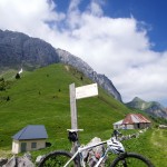
Just before the village, there is an easy-to-miss right turn onto another fabulous forestry road that heads up to Col du Plane (1337 metres). Again, it’s paved until roughly half way up, but then becomes gravel. It’s not as tough as Chérel, but there are a few very steep stretches. I even briefly pushed once. There are a few turn options, and my route doesn’t always take the most obvious turn. It’s worth GPS’ing the route to ensure you find the Col.


The descent again is gravel turning paved lower down entering another quiet, bucolic valley. Then a pleasant (flattish) few kilometres to Col des Leschaux (900 metres).

From Leschaux, it’s a fast 12 kilometre descent back to Lake Annecy. Overall a fun, scenic, challenging, very quiet, loop. But bring a mountain bike.