
For an overview map and details on every route I have cycled in the Pyrenées see here.

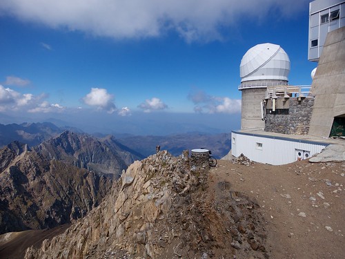
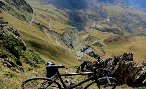
Above: view from Pic du Midi. Lac d’Oncet (2253 metres) below and the road above Tourmalet.

I’ve dreamed of doing this forever. Climb Col du Tourmalet, the most famous pass in the Pyrenées and then go much higher on an unpaved route to the towering Pic du Midi de Bigorre.
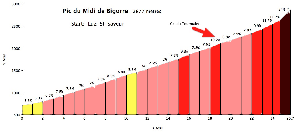

I started in Luz-Saint-Saveur, the bottom of the west side of Col du Tourmalet. I think this is the more scenic side (vs the La Mongie atrocity of a ski station on the east side).
While the road goes up from the start, it doesn’t really get interesting until about halfway after passing the town of Barèges.
Note, at roughly 10kms the route splits. There is a smaller road to the road now called the Voie Laurent Fignon. I suggest taking this. It’s the way the Tour has usually climbed. And even better, after the bridge, it’s closed to cars – a nice respite.
After less than 4 kms it rejoins the main road. As per the map above, I climbed this segment and descended the main road.
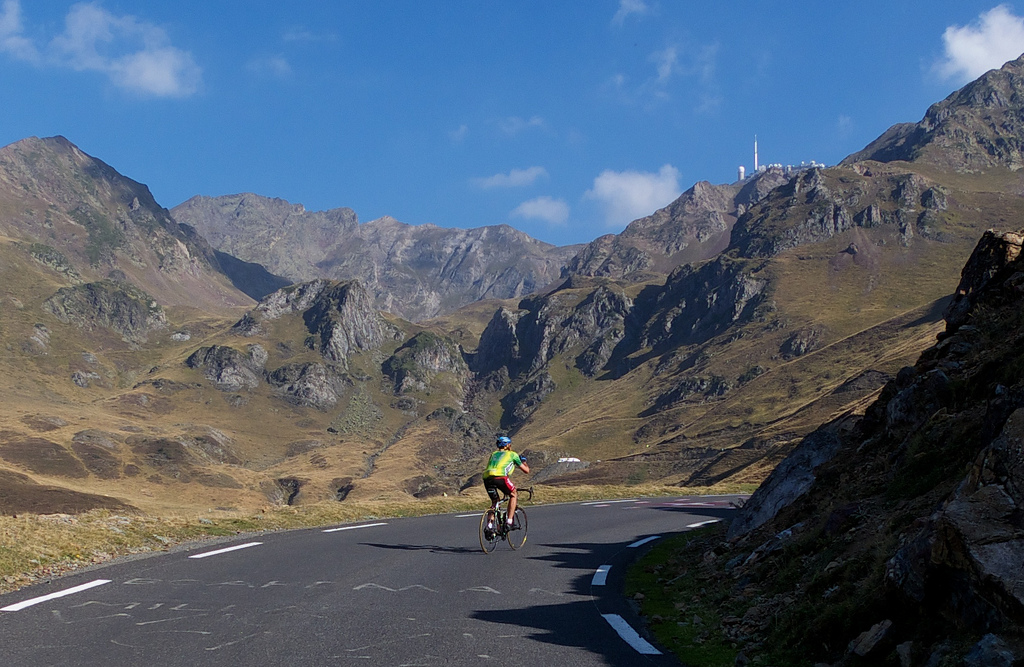
After rejoining the main road and looking up, I could see Pic du Midi – my goal – high in the mountains. I’d been riding for an hour and yet still had a very long way to go (pic includes a friendly stranger):
The last kilometre before Tourmalet is easily its toughest:

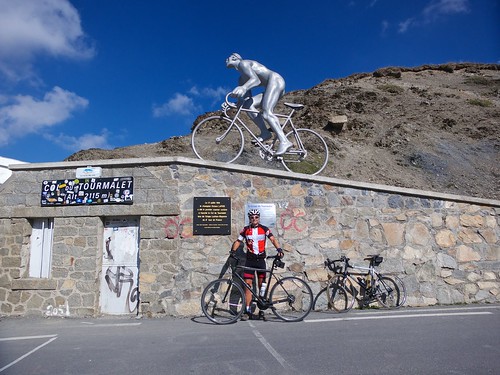
My previous two times up Tourmalet were too early in the season to see Le Géant du Tourmalet, so I was excited to get my photo with him:

After some refreshments, it was time to get to the real work at hand. The road up to Pic du Midi starts exactly at Col du Tourmalet. You cannot miss it beside the gift shop. It starts off with a few not-too-steep kilometres and a very good gravel surface.
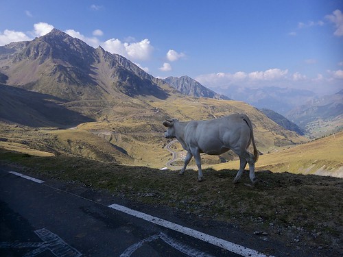
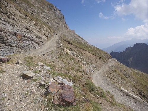
Lots of nice views of the Tourmalet road:

A view of Pic du Midi about 5 kilometres from summit (just before the really tough stuff started):

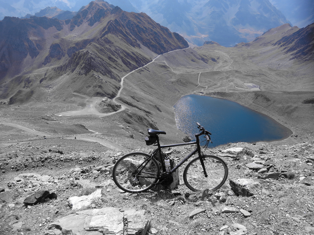
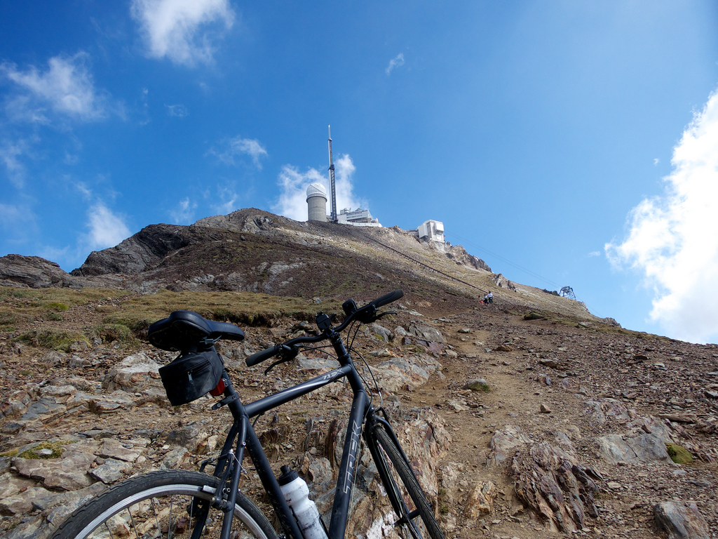
After about 4 kilometres the route reaches Col de Sencours and Lac d’Oncet beside it to the right. View from above:
From this point on things get harder. It’s steeper and the quality of the road deteriorates (slippery with lots of big stones).
But wow, it just keep getting funner and funner the higher it goes:

Steep and slippery! :

At Col des Laquets, the road basically ends. In fact the climbbybike profile just gives up here.
There is approximately 1 kilometre of hiking to be done and I carried the bike the entire way. I am not sure how steep it is, I put 24% on the profile given some GPS data, but I don’t know. The lower stretch isn’t terrible but it just gets harder.
But I wasn’t going to quit now. Time to hike:
I will say it’s easy to get in a conversation with anyone when you are carrying a bike in a place like this. So I chatted and rested a couple of times on the way up.
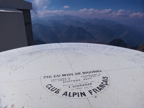
Finally:
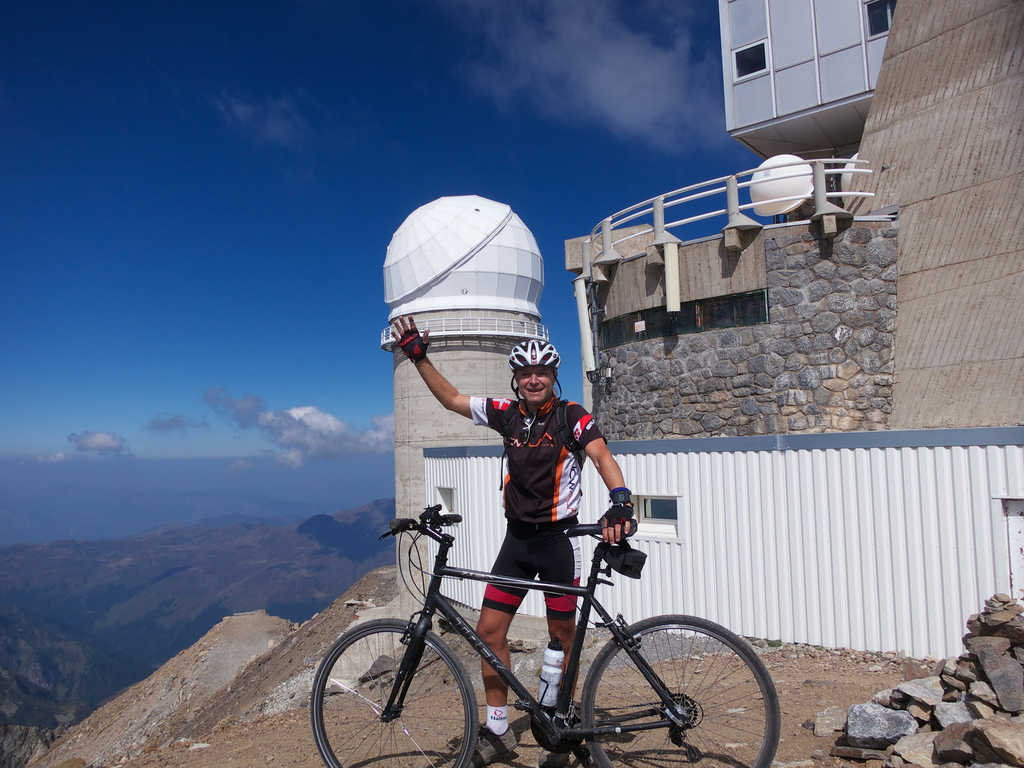
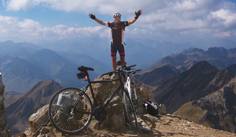

This is easily on my list of top 5 days on a bike. Unbelievably fun.
Maybe the best day ever on a bike. Woooohoooooo. If you get the chance. Do this ride.
-
Views
-
Difficulty
-
Quiet / No Traffic
-
Fun Factor


26 Comments
Chapeau.I have read one other account of this and the person ended up carrying their bike over snowfields.
My first time up the Tourmalet ended ignominiously at the summit when I couldn’t unclip and fell over in front of some French dustbin men. The only words I could utter were “Je suis fatigue” – which pretty much summed up the climb.
Woohoo ! Mais que fait cet hurluberlu au sommet avec un son vélo ?? 🙂
Pingback: Luz Ardiden : Cycling Challenge
Pingback: Pyrenées Trip Summary : Cycling Challenge
“I think this is the more scenic side (vs the La Mongie atrocity of a ski station on the east side).”
I couldn’t agree more!
Awesome effort riding all the way to Pic du Midi. I hiked up there back in July (and just wrote about it today coincidentally) and saw five or six mountain bikers up there. All of them carried their bike the last kilometer and I couldn’t see how it could be done any other way! It’s a tough hike even without a bike so big KUDOS to you!
Pingback: Array : Cycling Challenge
Pingback: inrng : roads to ride - col du tourmalet
That is a really cool trip. I intend to follow your advice and do this trip this summer. Looks absolutely stunning, thanks for your report!
Hi Will,
Re you blog ;
https://www.cycling-challenge.com/pic-du-midi-de-bigorre-via-col-du-tourmalet/
We are hoping to take the cable car, with our touring bikes and camping kit
http://www.flickr.com/photos/hillspecial/1779698655/
from La Mongie up to the top, July or August 2014
then look at the views, before the ride down the track to the tourmalet and then onto to near Gavarnie to camp for the next night,
We’ve been reading your blog – {and your other ones too !!} all looks rideable with our loaded touring bikes, 32 mm tyres, 700 c wheeled bikes, but the first km or so down from the observatory looks like a foot path – so does the track not continue right to the top then?
Do you think we’ll be able to push / carry our bikes , with panniers & saddlebags, camping kit , down this first km of foot path to the track?
We cycled up in 1995, 19 years ago by summer 2014 🙂 there were also cars using the track back then – we left our bikes at the edge of the car park and walked up the last km to the top – I have some photographs somewhere – pre digital camera days, 35 mm film camera – not scanned then in as yet.
As your blog is dated 2012, I hoped you might have some more recent information.
Thank you
Hill
On yer STEEL bike , I’d rather be cycling.
Think Bike, think work life balance.
http://www.bustedcarbon.com/
Dear Will
Congrats on the nice climb. I’ll be in the region next week – can’t wait!
One question: is it possible to ride to col de Sentcours with a roadbike?
Thanks on advance for the reply and best wishes,
Nicholas
Nicholas, it’s been a few years since I’ve been there, but it gets pretty rough after a while. But back when I did it, it was not too bad until Sencours. But …. it likely depends how fussy you are and if conditions have changed over the years. Beautiful though.
Hi Paul, yes, You can easily push your bikes down that top kilometre. It is a rough, rocky hiking trail, but if you take your time I see absolutely no problems. Parts of the road below get a little steep and rocky for a descent, but no problems if you are sensible. Riding up was one of the funnest days I have ever had on a bike. Beautiful place.
Gavarnie is great. Get above the tourist mess at Cirque de Gavarnie for quieter beauty — camping near Port de Boucharo would be amazing I think. Good luck.
Pingback: The Highest Unpaved Cycling Roads in the Alps
Hello Will,
first of all: Congratulations for your performance and your beautiful blog!
I found it while searching a profile of this climb in cyclist-databases, but I found nothing. Could it be, that nobody knows that’s the highest road of the pyrenees – and one of the most beautiful (not the Envalira) ?
I was so moved watching the beautiful pictures you made from Pic du Midi de Bigorre, remembering me the trip my brother and I made with touring bikes and luggage in 1991 (we made the Pyrenees from the Mediteranian Sea to the Atlantic coast as part of an11 month trip). We left our bikes at 2.650 m, at the last barn/hut and made the last km on foot.
I think you’re right in every word: This is an outstanding challenge, not only under sportive aspects, but of the so impressive landscape! It was one of our greatest days on our trip – and we had a lot rivaling ones!
I would like to send you some scans of old diapositives….
But I’m also writing to suggest you two other magnificant Cols in the Pyrennes. I checked your Pyrenees-Map and I saw a larger, uncycled area in the east of the Pyr.
So, try these two ones:
– Collade des Roques Blanches, 2.252 m (on the newest Michelin map 2.402 m) from Prats-de-Mollo la Preste to Mantet or (what I strongly recommend) following the mountain ridge to the Pla Guillem, sleeping in the mountain refuge not far away.
– Port de Cabus, 2.300 m, the frontier of Spain/Andorra, used by smugglers in ancient times (or even today?). Starting at the tiny village of Tor on the spanish side, descending to Massana (I made it in 1995)
If you made this, you may add the Port de Rat at the North, 2.540 m. Never made it, cause you have to carry your bike the last kms up- und downhill. But you will have a stunning downhill-route to through the valley of Vicdessos!
Both offer breathtaking landscapes! Try to stay the night on top as I made it and to watch the dawn and the rising sun in the morning!
Nice to hear from you and best wishes for all your journeys,
Martin (Germany)
I’m planning to ride up there (using a hired road bike) in early July. Looking forward to it! Thanks for the detailed information on the road conditions: much appreciated. I’ve ridden up the west side of Col du Tourmalet once, and this time I’ll be riding up that side again, but I’ll take the southern detour you mentioned, just to try something different.
Victor (Melbourne, Australia).
30 years ago I climbed the Tourmalet and then the Pic du Midii de Bigorre on my cross bike. It was a fantastic ride with beautiful views. It was good training for the 3 Peaks Cyclo-Cross that I rode 45 times.
Bravo congratulations
super cet article et photos très belles, ça donne envie
en ce moment ton lien tourne sur le forum velo101 et ça plait beaucoup
Looks awesome. I’m doing Tourmalet in June and might just add the peak. I’ll have a road bike with 25mm tyres. I noticed you had a gravel bike with wider tyres. Do you think it would be doable (except the last km) on a roadie?
it’s been a while, but the top stretches were quite rough (look closely to a few of the photos). It all depends how fussy you are. You may just have to descend some stretches very slowly. Brilliant climb.
is the top section still open for cyclists/walkers? On Google maps I see signs that show that bikes are not welcome.
Above the end of the road? I never saw signs but that was a long time ago. But at the summit is more like a platform area and I could see cycling not being allowed there as people come up via a cable car. I only pushed my back and walked at the top. But anything below is pretty remote.
The top section is open. There’s also a sign that you’re not allowed to walk, just means that you enter at your own risk.
Thanks so much for your report! I was in the area last week and you inspired me to give this one a go on my gravelbike. Started 6k before Luz to warm the legs up a little. I started climbing around 3pm, and had very little traffic and cyclists along the way. Slowly climbed up the Tourmalet in order to save the legs for the last part to the Pic.
The top of the Tourmalet was cloudy and quite chilly, but after some offroad climbing, the sun and the gorgeous views were back. As I have no suspension and 42mm tires with quite vulnerable sidewalls I had to use all the concentration I had to ride between the sharper rocks. Had to put my foot down on two parts that were quite steep. The lack of oxygen at this height doesn’t help either!
I only met hikers and lama’s here, not a single cyclist in view. The hikers cheered and applauded, every bit of motivation helps at this height 🙂
This was my first col ever, easily my best day on a bike yet! Amazing climb, amazing views. And the hike to the top is literally breathtaking!
First col and you made it to Pic du Midi !!!!!!!! Congratulations, very well done!
So we were in a tiny place called Aurignac on a family holiday, I took the gravel bike and was about to try a gravel route elsewhere but saw your site and how could I attempt anything else after your writeup.
Suffice to say, it was as good as billed and more. not sure this link works but hey:
https://www.strava.com/activities/9564025387
Am especially proud as 2 years almost to the day, a bike accident left my right leg paralysed. Now have recovered most of the function above the knee and some below; cycling is fine but the hike a bike was a challenge I can tell you. but what an awesome way to bookmark a recovery in progress. thanks for writing this up. will be trying more of your routes. Shane
Brilliant climb, spectacular views and indeed one of the best rides ever in my life…. I used a mtb, reached Pic du Midi with my YT Jeffsy and waited for friends using the cable lift… 🙂
Nice comments at the platform on reaching it by bike and on descending went downhill off piste eastwards (only one hiker seen!) and re-climbed Tourmalet on the road again from that side.
https://www.strava.com/activities/5706231370
Epic area, the Pyrenees….