

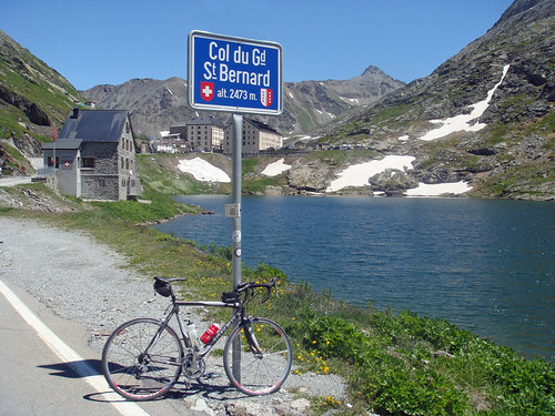
Col du Grand Saint Bernard is one of the highest Cycling Cols in the Alps at 2,469 metres (8,100 feet). And one of the longest at 45 kms from the Swiss side.

A Little history
This pass has been used for almost 3,000 years to cross the Alps. Julius Caesar crossed with an army in 57 BC. Today, along the route are signs with drawings commemorating Napoleon’s crossing with 46,000 soldiers in 1800.
In the 900’s Saint Bernard of Menthon opened a Hospice to provide a safe haven for travellers – the hospice is still operating today.
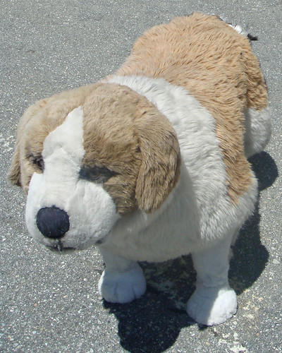
The Saint Bernard dog was first mentioned in 1709 and has become an icon of the alps. Stuffed versions were on sale everywhere at the top.
Back to Cycling
I prefer beautiful routes to complete routes and I have avoided this great pass for a long time because quite honestly the lower part of the Swiss side is a lousy route. It’s on a main road with fast traffic and plenty of tunnels; and trucks heading for Italy.
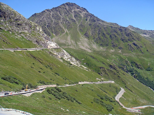
But as the route climbs, seven kms from the Col, the main road becomes a huge tunnel right through the Alps. And there is a little turn off to the old route (trucks are forbidden). From here on it’s a great ride.
My cunning plan: Drive to this turn-off and cycle up. And then descend the other side into Italy until the old route meets up with the main road again.
While purists will be appalled at not “doing the whole climb”, this worked perfectly for me and by combining two climbs it still resulted in almost 1500 metres (5000 feet) of climb.
It wasn’t just the natilly dressed Italian customs officers that let me know I was in Italy. The road surface was awful on the south side.
EDIT 2012: Since the Tour crossed the St Bernard a couple of years back, the Italian side has been resurfaced. Smooooooth.
A wonderful ride on epic, very high, safe roads. Makes sense to me.


Complete elevation profiles from the Swiss (Martigny start) and Italian (Aoste start) sides:


Here’s a link to details of the Col du Petit Saint Bernard. Nearby climb that links France and Italy.


26 Comments
What are you using to track your rides or what software gives you all these great graphics?
Hello Hilton,
If you mean the elevation profiles …. I make them myself using info from a book, a french cycling software program, and Paint Shop Pro …. better than copying …
Italy! So, when are we going to ride from home and do a 3-country ride? Switzerland, France and Italy – in one day?
Looks like this was a great col with lots of history. Italy’s roads are worse than in France? Yikes!
Aren’t you starting the Tour de’Enfer soon?
Anyway… Great history lessons you offer! Do you think it would help if you carried a little barrel of whiskey on your bike as did the Saint Bernard around his neck? OK… maybe that whiskey barrel is a legend but it’s still a good story. Cheers!
Martin,
Yikes. this climb is probably the best way to get to Italy in one day from home by bike, and we can get France by using the South side of Lake geneva. but I am returning by train 🙂
Donald
Next Saturday is the kick-off BBQ at my house for the tour d’enfer. I will expect you late afternoon.
Thanks for the info Will. I was planning to do this climb from the Italian side as part of my current tour. But after looking at your elevation profile I might need to think again.
Pas mal les profils Will ! Je ne savais pas trop d’où ils venaient…
Moi je prends ceux du site “Salite”, avec l’accord du concepteur.
Bast,
Ce site francais
http://vsprint.com/
a un logiciel qui fait les profils (avec l’info en mes livres) et des coleurs ajouté.
Pingback: Bookmarks about Epic
Totally agree with your description of the Swiss side from Martigny. It is very well signposted from the train station but the road is very busy and simply too narrow to allow bikes and other traffic.
Just before the quiet last 4 miles there is a 6km 3-sided tunnel which is also terrifying as the noise from approaching traffic from behind roars like an airplane taking off.
Heading back to Chamonix, bikes are only allowed on certain trains. Outside of peak season no-one seems to complain it you take in on any train. be careful of trains where you have to change to another train at the swiss border and ones that are direct but stop for a long time at the border as another very inviting train arrives on the other platform … arghh!
Hi I cycled this pass on route to Florence from Leeds you will be glad to know the Italian side has been resurfaced which was a surprise, I had braced myself for the worst but in the end it was a great decent to Aosta in the sun
It was the first time I had dozed off while on my bike.
The Italian side looked beautiful with its wooded mountain sides new roads including wood clad safety barriers the traffic was quite at 14:00 all the Italians where asleep a massive contrast to the accent from Martigny.
Hello
So even though the road maybe busy and narrow, is it legal to still ride on the road? or is it best not?
Thanks
Jonny,
yes, you can cycle on the main road all the way from Martigny until the tunnel …. then bicycles must take the better “old” road
Pingback: Switzerland to France: Tasch to Chamonix « Another Header
Hi Will,
Cracking good site mate- I have been using it for the last two years and it is always bang on. Rode the St Bernard this morning from above the tunnel on the Swiss side. Gorgeous morning with the sunrise greeting me at the top. The Italian side has clearly been resurfaced and looks like a life sized slot car track – perfect.
Cheers
Sean
Bristol and Brisbane
Pingback: All roads lead to Rome, a summer 2010 adventure. | Commuter to Cat 3
Pingback: Geneva to Milan: with some mountains in between | Riding ROUND
Pingback: The Ten Highest Paved Cycling Climbs in Switzerland
Hi, Interesting article thanks. I plan to cycle from Italian side to swizz side, I have found the tunnel mentioned above on google maps, but where abouts is the ‘old road’ and is it easy to see on the map or satellite view?
Thanks
Dan
If you climb the Italian side, when you cross into Switzerland you are ON the old road. 6 kms or so lower and the old road intersect with all the cars exiting the tunnel
I am planning a cycling trip through France and Italy and a little bit of Switzerland, my question for you is: if you were cycling from Geneva into Italy what route would have the least amount of traffic? Cycling the St Bernard Pass looks amazing but your description of all the lorries and tunnels makes it sound less appealing.
The Italian side of Grand St Bernard is truly amazing, but that’s because it quickly bypasses the main road to the fast-traffic tunnel linking Italy and Switzerland. But on the Swiss side the entrance to the tunnel is far higher and the cyclist is forced to share the road for a VERY long way. I truly don’t think cycling up the entire Swiss side is fun.
If your cycling through France consider one of the northern links with Italy such as Col du Mont-Cenis or Petit-St. Bernard (via Colle San Carlo on Italian side is best whether climbing or descending Italian side to avoid tunnels and busy traffic on lower stretch of Petit St. Bernard). Or several other good Italian/French options as one heads further south.
If you wanted to ride Grand St Bernard from Martigny, the best would be to ride over Champex to Orsières (quiet road), then take the postal bus to Bourg Saint Bernard where the pretty road begins (or else take the bus in Liddes or Bourg St Pierre). That way you skip the tunnels and the traffic. It’s a much better crossing the other way, since you’d be riding the nasty section downhill at the speed of cars, it’s over in 10 minutes. From Aosta there are several smallish roads that would enable you to avoid traffic entirely.
Its hard to give advice without more info about your route. I agree that much better crossings are between France and Italy further South (Petit SB, Mt Cenis, and esp. Agnel), or much further East, from Switzerland (Spluga, Bernina, Umbrail/Stelvio)
Thanks for you response. My route is far from certain at this time, as of now I am planning on starting in Lyon France and ending in Rome, but even that could change. I have the time, health and $ to go to Europe for about 10 weeks, I will camp half the time. I rode from Munich to Tirana Albania last year and want to see more mountains this time. Do you have any route recommendations on where I should go?
Oh man, where to start…
I’d make my way to the Vercors and ride up the spectacular gorge roads and enjoy the quiet plateau. Exit South to Die over Rousset. There is an endless network of small quiet hilly roads extending South to the Ventoux and Lure mountains, just get a 200k Michelin map and stay on the white and narrow (they have a map that covers the whole southern alps). Then the bigger stuff: East toward Digne and over Cayolle or Allos to Barcelonnette to the North, over col de Vars to Guillestre, then over Agnel into Italy. In Sampeyre turn South over col Sampeyre then Fauniera to Demonte. Then you might head South to Limone (unfortunately a big road) and colle Tenda, where you could descend the famous switchbacks, or (better) stay on the Western rim on an easy dirt road and make your way to Casterino. From there descend to the sea at Ventimiglia. Or from Demonte ride further East toward Garessio and cross into Liguria. I’ll leave you there…
I’m sure you ask 10 people you’ll get 10 routes.
to add
Since you have 10 wks you can add lots of additional loops, e.g. Bonnette/Moutière from Barcelonnette, Izoard from Guillestre, or even a bigger loop to the North to include Galibier, Iseran, Mt Cenis, Finestre