Here is a fantastic loop of Lake Annecy – with two long, high, tough, gravel stretches – that visits two Cols that you may not know. But if you don’t like pushing your bike for a stretch or two then this ride is not for you.

A 3D video of the ride.
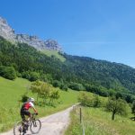
I started on the north edge of Lake Annecy and headed counter-clockwise around the lake. I advise you to zoom and follow my route exactly – see map at bottom – as it is perhaps the quietest way to escape Annecy here. There is one short stretch of gravel below Menthon as the route begins to head up.
Note, for virtually all my posts, you can download a gpx file of the route by clicking on the route link on the map.
The route briefly joins the main road to Col de la Forclaz, but immediately after the tunnel at Ermitage St-Germain, turn onto a tiny, hyper steep paved road. At times, this is either side of 20% but a good surface. I grinded my way along finally reaching the first of two long gravel stretches at the Route de la Coche (roughly 900m).
Here is a road bike loop of Lake Annecy that runs below the gravel stretches via Col de la Forclaz de Montmin.


It’s pleasant for a couple of kilometres but then I turned up an extremely steep, and difficult to ride forestry road leading to Col des Nantets. A few years back, I was standing at Col de l’Aulp and could see a twisting road to Col des Nantets. But this road is not on IGN, Google, or Open Street maps. There I could only find nearby hiking trails. But I found recent satellite photos clearly confirming the road. So here I was.
I try not to be too dramatic about how difficult climbs are, but rather just provide you info. This 3 km stretch? I could rarely pedal. Just too slippery, stony, and steep for me – but it’s a road, not a trail. Consider yourself warned. But no worries, it’s a nice hike. 🙂

Nearing the summit, the trees mainly disappear, and there is a cross at Col des Nantets (1426 metres). There is no road over the top, just steep hiking trails down.

Col de l’Aulp (1424m) is just two kilometres away but it’s down then up. This is the only part of the ride that is trails, not road. And again, I had to hike some of the up stretches. But it’s not far and some of the lake views are great.


I soon reached Col de l’Aulp. Below is the view of the unmapped hairpins to Col des Nantets that I mentioned above:

The far side of Col de l’Aulp is far more ride-able – see here. The road starts near Montmin (a couple of kms below Col de la Forclaz) – with the final 2.5 kilometres gravel. A truly stunning stretch of road under La Tournette (the highest peak around the lake):

I descended Aulp, rejoining the main Forclaz road, deciding not to visit the Col, but instead heading in the opposite direction. Soon, below Montmin, I turned left up a small road to Plan Montmin. Here begins the second long gravel section. This starts peacefully enough, gently climbing higher, with plenty of fun views of the valley far below.


But the descent back to civilisation is crazy steep. I am the worst mountain-bike descender ever so I gingerly walked a few stretches, but it’s road, not a trail. I am sure better riders will have more luck/fun. Finally, after a quick traverse on quiet roads near Faverges, I joined the Annecy bike path for 25 flat, peaceful, enjoyable kilometres – completing the lake loop.

Not bad, not bad at all.

At times very difficult, the two long gravel sections, and the trails between cols are a blast - although some of the pushing to Col des Nantets less so.
-
Difficulty
-
Views
-
Quiet / No Traffic
-
Fun Factor
2 Comments
Have walked some of that above Montmin and mountain biked down to Talloires from top through the woods! Fab.
Will be back in Doussard again in few weeks for our annual alpine fix! Just road bikes this time though
Thank you so much for posting and documenting this. I’ve been seeing these gravel sections while paragliding above the lake and wondered how to ride to the top, couldn’t find a way on Google Maps. Gonna try this in August.