

One of the more amazing cycling trips I’ve ever done. A three day loop around the Mont Blanc Massif by mountain bike through France, Italy, and Switzerland with endless glacier views. Paradise. I rode with my friend Alfie, the President/King of the Steel Wheelers, my local cycling club.
- See here for details of Day 2 – Entrèves (Italy) to Champex (Switzerland) via Grand Col Ferret.
- See here for details of Day 3 – Champex (Switzerland) to Les Contamines (France)
WARNING! This loop requires LOTS of bike carrying – both uphill and down. Much of the route, especially the higher slopes, are on steep, rocky, difficult mountain terrain. It’s often completely unrideable regardless of how strong a cyclist you might be. But, many of my favourite stretches along this stunning circuit were along these unrideable parts. Our average moving speed on Day 1 was barely 6 km/h. 🙂

This post will detail day 1 of our 3 day trip. At the bottom of the post is a second map showing the entire 3-day route. As usual, there will be lots of photos.

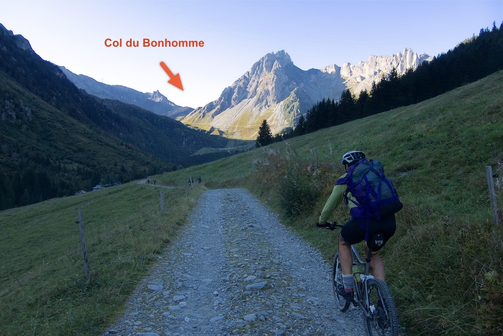
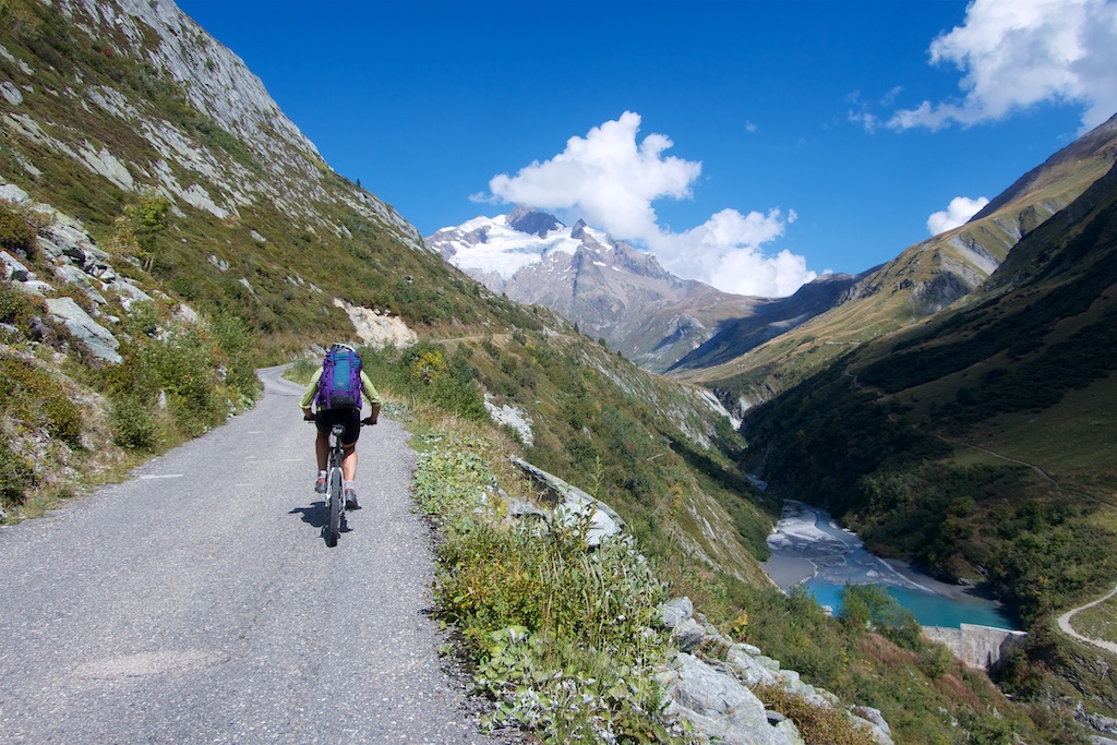
DAY 1 – Les Contamines to Entrèves
Les Contamines to Col du Bonhomme
Starting from Les Contamines we jumped onto some trails and soon reached Notre Dame de la Gorge. This is the start of the unpaved La Voie Romaine that leads to the Col. It’s a “road” until roughly 2000 metres, but often very, very steep especially early on.
Roman coins have been found at the col, but it’s an exaggeration to think this is an old Roman road. For example, the Pont Romain was built in 1780.


Above 2000 metres, the road becomes a hiking trail. It’s sometimes rideable, but often bike carrying is required. The majority of our 3 day journey would follow the main TMB route (and occasionally official secondary options). The TMB (Tour du Mont Blanc) is a popular official hiking route so it’s always a well-signed and well-used trail.
At the end of the road is another trail that leads to the beautiful Lac(s) Jovet (there are 2 lakes with the same name). I’ve visited there by mountain bike – details here.

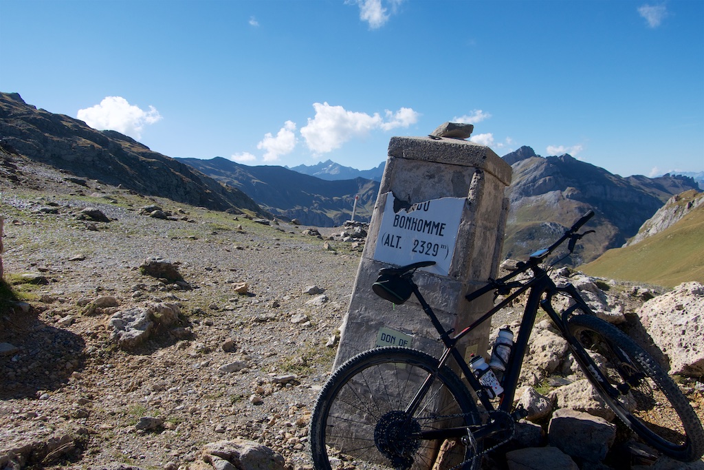
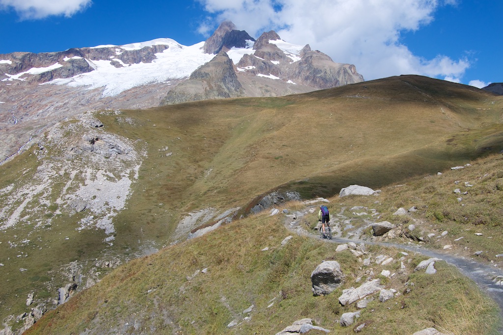
Col du Bonhomme is at 2329 metres and has wonderful views in every direction.

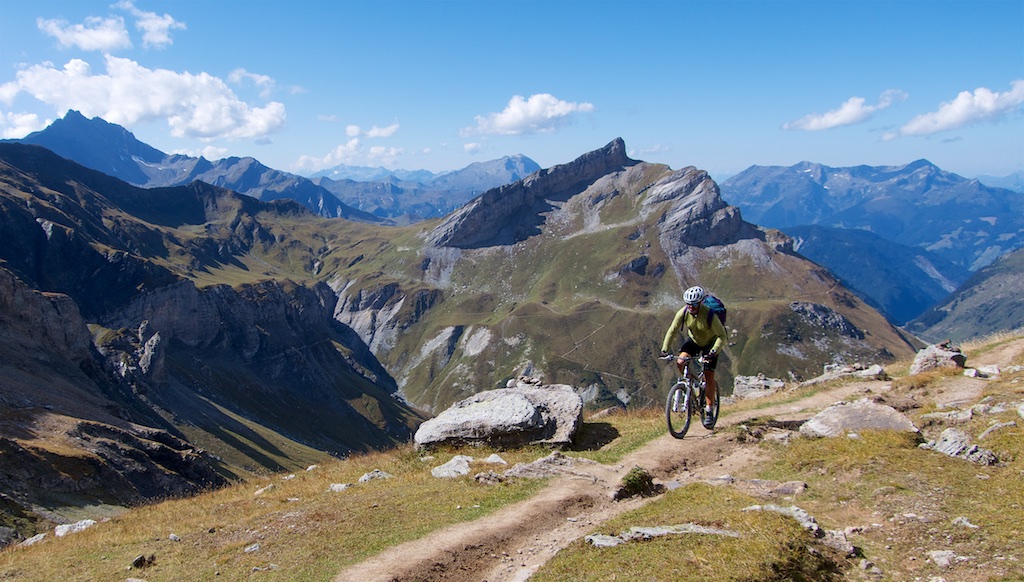
The Col is not the high point though. We would head higher on a great ridge stretch summiting at 2479 metres just above the Refuge du Col de la Croix du Bonhomme (2433m) and Col de la Croix du Bonhomme (2410m).

Descent to Les Chapieux
As the profile on the above map shows, the descent to Les Chapieux is often very steep. It’s mainly trails, not dangerous, but you better have adjusted your brakes.


Les Chapieux to Col de la Seigne
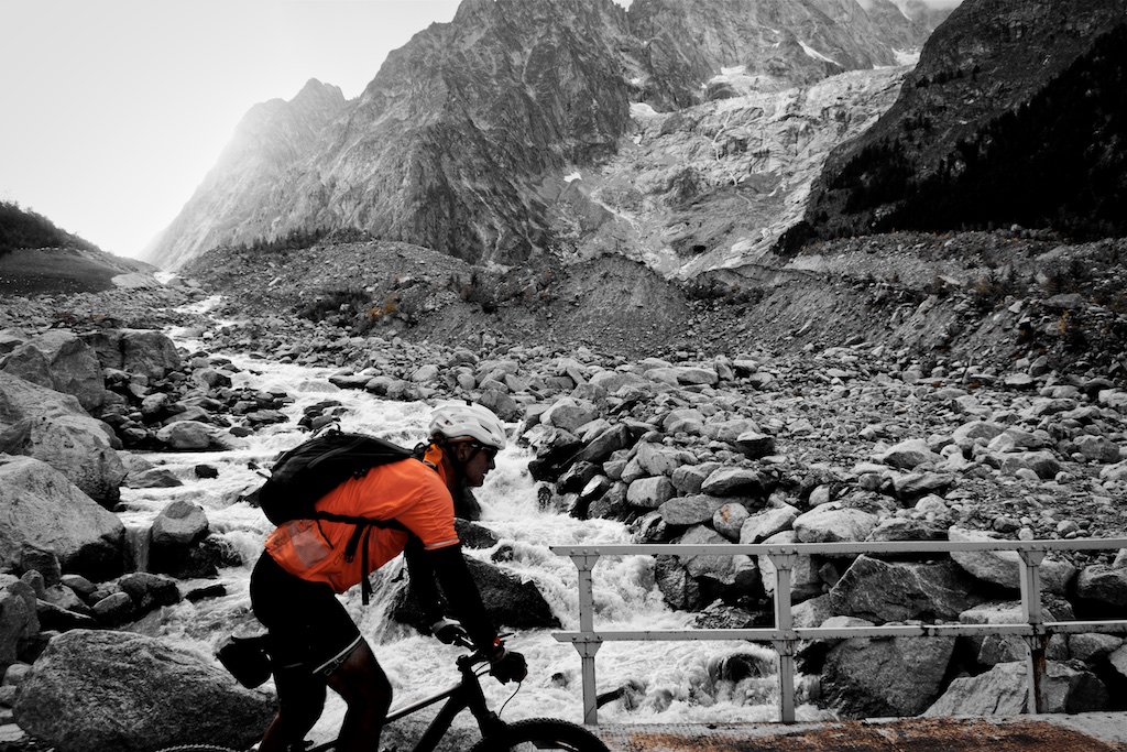
We took the steep little paved road to La Ville des Glaciers, but as the photo below shows, there is a possible trail option on the right side of the torrent/river. It was exciting when the wonderfully named Glacier des Glaciers came into view:
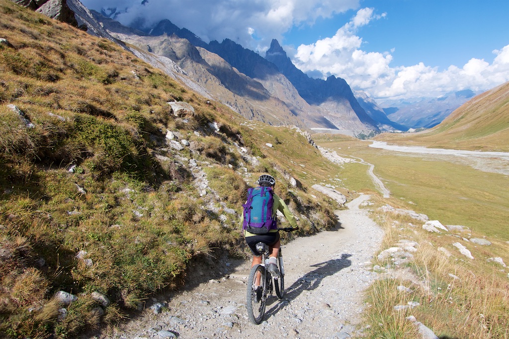
At La Villes des Glaciers we turned right onto a gravel road that would soon turn into a hiking trail. Again, it becomes very steep and technical at times. We would cycle easiers stretches and push the rest. But we were both very cheerful. What a place!


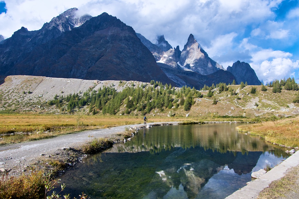
Col de la Seigne (2516 metres) is the French/Italian border. We could see a cloudy covered Mont Blanc in the distance.

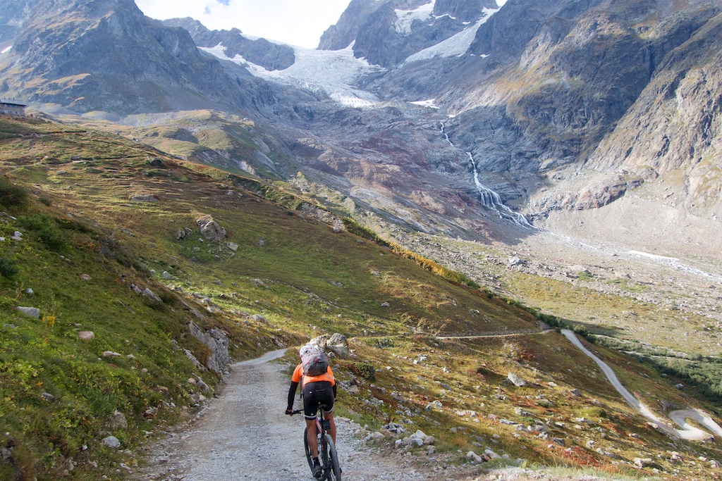
Descent to Entrèves
The descent to our Day 1 end-point of Entrèves (just above Courmayeur) through the Val Veny is phenomenal. It’s a touch technical at first then completely rideable. On our left we passed glacier after glacier as we got closer to Mont Blanc. I don’t have the adjectives to do this justice.


Note, near the bottom of the descent we took a left onto a quiet gravel road that allowed us to avoid descending down low into/below Courmayeur, instead passing the entrance of the Mont Blanc tunnel into the village of Entrèves.
Woohoo, this was a brilliant first day – every turn seemed to reveal a new, beautiful view. But again, this stage was far more difficult than the stats might indicate. We laughed a lot at our average speed which seemed to hover around 5 km/h until our final descent raised it above 6! But carrying a bike up a mountain trail can be slow. We are not fast but we’re both reasonably fit and this 50 kilometre stage took us over eight hours of moving time. 😉


13 Comments
That is an area I want to return to and make a nice tour someday! Thanks for sharing your trip photos and blog. I have a gravel bike but not mountain bike, could a tour like this be completed on gravel bike?
Ryan, I suppose. It depends how fussy you are. But this particular ride is really designed for a mountain bike. Lots of very bumpy, technical descending.
Looks fantastic. Great work.
Hi,
I’m considering doing the same trip this summer. How experienced should you be on a mountain bike before doing this trip? Do you know how difficult it is compared to the Sella Ronda MTB Tour in Italy?
Did you have to book the accommodation in advance or can you just show up the same day? 🙂
Thanks!
Sorry, I don’t know Sella Ronda Mtb Tour. This loop is tough, with quite a lot of pushing – it’s not designed for bikes. We’re pretty average but it took us 3 full days. I wouldn’t recommend this to someone not used to at least some full day rides that require pushing the bike for long periods. But it’s a beautiful loop.
Accomodations? I don’t know. I think it’s worth planning ahead, especially in summer as there aren’t many options in lots of places along the route.
I did the 3country tour….basically this tour…..with MBMB in ’06 @ 65yrs old. It was definitely a challenge for a Florida “boy”. It was truly a trip of a lifetime for me and these pics/accounts are bringing back great memories. I Rx MBMB out of Chamonix. Don’t miss it if you are even of medium conditioning and skills. There will be some “walk a bike”, but I wouldn’t have missed it.
Good afternoon,
My boyfriend and I are planning a trip to Europe including a tour of the Mont Blanc this coming August. How did you get information to decide on your itinerary? There seems to be so many route options it gets a bit confusing. Thank you!
I know the region fairly well so I mapped it myself but the Chamonix tourist office might be a good source of info. I think for hiking there is an official route. They will almost certainly respond to detailed questions. https://www.chamonix.com/tourist-office,99,en.html
I would like to say thank you for the advice on doing the road version of the tour Mt Blanc. I did it over three days. Going anti clockwise starting in Les Arcs 1950 where I was staying, so 25km downhill to the town Bourg st Maurice. !st night stop was Aosta Italy, 2nd night Argentiere and finish back at the start St Maurice. very hot (30c+) three days, at least 5lts of drink per day. I t me 3.5 hours to get up the Grand St Bernard hundreds of motor bikes and I do mean hundreds two conveys of 40+ bikes. the best climbs were the petite St Bernard and the Comet de Roselend. The thing I didn’t like was the long tunnels on the Swiss side of the Grand St Bernard too noisy. Once again many thanks. Next is the Atlantic to the Med over the Pyrenees. Any advice from any one would be appreciated. Steve McB
Well done Stephen. Yes, the #1 tip is to do it counter-clockwise so one climbs the amazing Italian side of Grand St Bernard and descends the not great Swiss side. yeah, motorbikes can make summer difficult.
Any tips for the atlantic to med
HI will, clockwise or counter clockwise which is the best loop to ride in TMB? mind to share your gpx file to me? my email is ivanngcm@yahoo.com
Hi Ivan,
I have emailed you the gpx file.
We rode anti-clockwise. I often have strong opinions on directions of loops but I really don’t have a strong opinion here.