
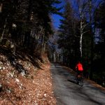
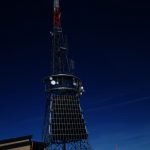
The Swisscom Telecommunication tower at La Barillette high in the Jura mountains is visible far below from Geneva. One can also see the white bubble airplane radar tower atop the La Dôle peak. It’s thirteen wonderfully deserted kilometres to the summit up a beautiful, paved forest road.
I try to use Strava to follow friends and acquaintances that do interesting rides. For La Barillette, every year I wait to see that a friend has reached the top, then I immediately visit. Usually, the route is not clear of snow until April. But it’s been a warm winter. My good friend Tim lives near the base of this climb and managed to reach the top the other day. Woohoo, well done Tim. I saw his photos on Strava and I was on my way to visit too. 🙂
La Barillette is the 3rd highest paved road in the Jura mountains. See here for details of the 10 highest paved roads in the Juras.


I didn’t see a car the entire way as the road was closed part way up.

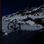
The road was completely clear except for one patch of ice near the summit. I hiked through the snow to avoid it.

A two-minute video of the ride:

See here for an unpaved route up to La Barillette.
The view from Swisscom tower at La Barillette:


4 Comments
Thanks Will!
This cattle grid was truly a “Barrière Canadienne“ – covered in ice!
Great video thanks for uploading. Is there still a lot of tree debris towards the bottom of the descent/would you recommend normal road bike tyres?
There wasn’t any debris the day I rode up. Since then, I think it reclosed due to snow. Not certain the status currently.
What a challenging ride. Amazing article and photos.