

I often receive emails asking if Col xyz will be open in late September/October. Depending on the col’s altitude and the month, I try and give an intelligent response that usually can be summarised as either no, maybe, probably, or possibly.
Question: Will Col du Galibier by bike-able in late October?
Me: No, I seriously doubt it.
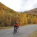
But it was in fact still open. A perfect day, I decided to visit Col du Galibier one last time before it closes until next June – it should snow there tomorrow. I started down in St-Michel-de-Maurienne at the base of Col du Télégraphe. I always enjoy Télégraphe, not too steep and nice views. It was a beautiful autumn day:

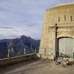
Below: Fort du Télégraphe at top left:

Behind the Col du Télégraphe col sign was a giant straw man:

The Fort du Télégraphe is strategically perched high above the Maurienne valley. Built in the late 1880’s. It’s never seen serious action, but there is a memorial there for several French soldiers killed by the Nazi’s. It is still used by the French military and can be visited by tourists in the summer.
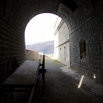
I took a short detour at Télégraphe on the way back down to try and visit the Fort for the first time. It’s roughly one kilometre on a dead-end uphill road. Unfortunately the Fort was shut.
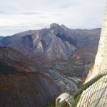
Here’s a view of the Fort from across the valley from a ride last year:

My least favourite part of the north side of Galibier is the 8 kms above Valloire. Steep and fairly straight (and a head-wind today). I want hairpins! I struggled slowly up as usual. But once the route reaches Plan Lachat at 2000 metres altitude, the last 8 kilometres are a dream. Stunning.
Below is the 6 kilometre marker. Behind is the great unpaved road to Col des Rochilles linked to further down in this article.

Making progress:

Yes, I know. I have written a lot about Galibier. Sorry. But in case you’re interested, here are a few links to older posts:
- Details of all three sides by road bike
- A slightly crazy 4th way up – bypassing Télégraphe
- Cycling Galibier to see the Sun Rise
- La Marmotte Cyclosportive – Glandon/Alpe d’Huez/Galibier
- Watching the Tour de France up Galibier: North side and South Side
- A Brief History of Col du Galibier
- Col des Rochilles – Superb high Mountain Bike Trail off north side
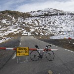
Today, the road was closed above the tunnel to cars. But it was easy to bypass the barrier. It was clear why the road was closed as there was some ice on the last half kilometre. I took my time, dismounting a couple of times. But no worries.

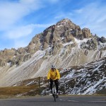
It was 2°C at the summit and windy, brrrr. Completely deserted, very peaceful. I hiked above the Col for a photo of both sides. It’s easy to guess the north side:


This is a difficult climb, and I was tired and slow. But wandering around the summit of Galibier is always satisfying. It’s an amazing place. It’s also a long way down. But, I had plenty of extra clothes and full-finger gloves so the descent wasn’t too cold. 🙂
Galibier in late October? A true treat. Very fun to squeeze in one final high climb before winter closes them for months.
4 Comments
Great blog, very nice pictures, where do you get these nice gradient profiles from?
For the gradient profiles, I make them myself using an old Mac program: Omnigraphsketcher
who is taking the pictures? awesome!!
My trusty mini tripod 🙂